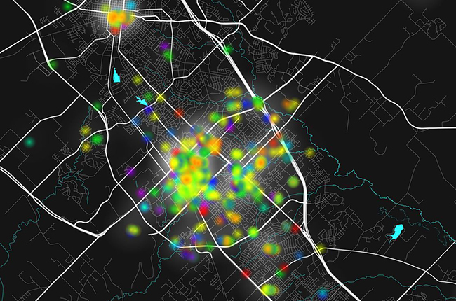
This spring, Austin artist Jennifer Chenoweth is leading an army of volunteers to create a public art project, the “XYZ Atlas,” a color-coded data-based map that will geographically plot where individuals experienced emotional highs and lows within the Bryan/College Station area.
Helping Chenoweth realize the project are numerous Texas A&M, public and civic groups, including Texas Target Communities, a Texas A&M College of Architecture outreach unit providing urban planning for Texas communities in need.
“The project is an interactive, public art piece, a record of the emotional influence the region has on its residents,” said Chenoweth, who completed a similar project, XYZ Atlas: The Hedonic Map of Austin, prior to focusing on the Brazos Valley. “The atlas creates a community’s identity through a shared sense of place. It also reveals and helps us visualize how we are connected — to one another and to our surroundings.”
Created using geographic information system software, the project is scheduled to debut May 5 at downtown Bryan’s First Friday event. The “XYZ Atlas” will be interpreted through a variety of media including 3-D printed objects, handmade drawings, interactive digital maps and sculptures.
“Few projects have this kind of insight into where and how people experience their strongest emotions,” said Chenoweth. “My hope is that the collected information will help make Bryan and College Station more inclusive, healthy and meaningful to its residents.”
The data gathered so far has been used as teaching tool in an undergraduate urban economic development class led by Cecilia Giusti, associate professor of planning.
“Students are learning that this kind of data can be an additional dimension, along with income, race, and gender, in a spatial analysis of a city’s economy,” she said.
Giusti plans to employ the project’s complete dataset on future teaching and research projects.
The map is shaped by data provided by area residents who complete an anonymous online questionnaire, available in English or Spanish. Additionally, booths staffed by XYZ Atlas volunteers will survey people during a series of planned public events throughout the region. The questionnaire asks participants to note where within Bryan/College Station they experienced specific emotions, such as joy, fear, sadness, anticipation, anger and surprise. In turn, the data will be compiled to create an emotional topographic map of the region.
To increase survey participation by minority populations in the area, Texas Target Communities has enlisted graduate planning students experienced in community development and civic engagement projects to collect data for the atlas.
Their efforts have led to XYZ data-collecting booths at events hosted by African-American and Hispanic groups on campus and throughout the community.
“The XYZ Atlas project not only delivers beautiful art and valuable data, it is also grounded in participatory planning practices that gather input from diverse population groups within a community,” said Jaime Masterson, TTC program coordinator. “We are thrilled to be a part of it.”
XYZ Atlas booths will also be set up in Bryan at the April First Friday event in downtown, at the April 8 Street Art Fair and other community events.
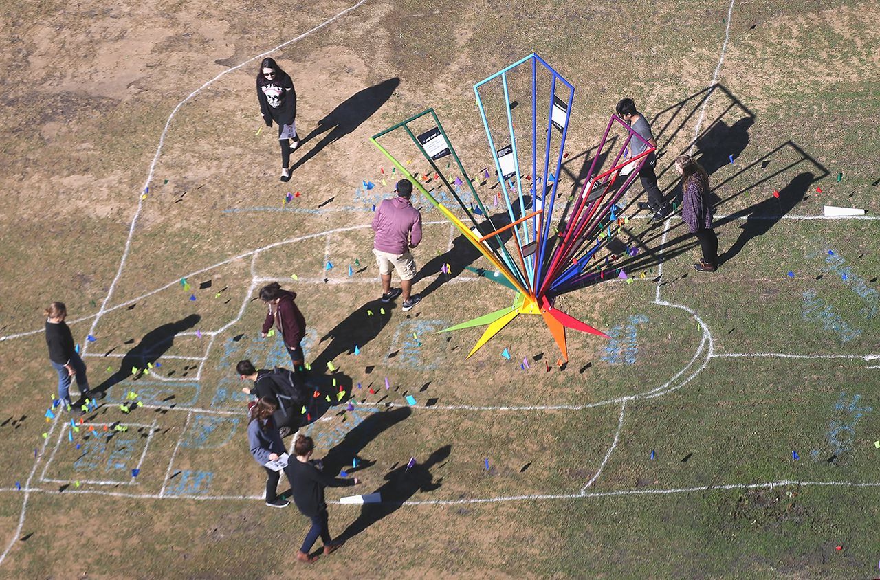
The B/CS atlas project expands a project initiated by Chenoweth as part of the November 2015 GIS Day celebration at Texas A&M. The GIS day event, staged on the lawn south of the Langford Architecture Center, encouraged participants to place flags, color-coded to represent specific emotions, on a giant chalk outline of Bryan/College Station.
Also collaborating on the B/CS XYZ Atlas are the Texas A&M College of Architecture Diversity Council, Campus Climate Grant office in the Division of Student Affairs at Texas A&M, Blinn College, cities of Bryan and College Station, Arts Council of Brazos Valley, Bryan/College Station Convention and Visitor’s Bureau, Village restaurant, Texas Cultural Trust, and Downtown Bryan Association.
The project’s funding comes from various sources, including the National Endowment for the Arts, the Texas Commission for the Arts, and the Mid-America Arts Alliance.
###
This story by Richard Nira was originally posted on ArchOne.