Texas A&M Study: Rivers, Streams Cover Larger Portion Of Earth’s Surface Than Previously Thought
Rivers and streams cover more of the Earth than previously thought and therefore play a greater role in controlling concentrations of greenhouse gasses in the atmosphere, according to a study led by a Texas A&M University hydrologist.
George Allen, an assistant professor of geography in the College of Geosciences at Texas A&M, and colleague Tamlin Pavelsky at the University of North Carolina at Chapel Hill will have their work released today in Science magazine.
Using satellite images from NASA, the team developed the Global River Widths from Landsat (GRWL) Database, the most comprehensive global map of river length and width.
“We were able to measure over two million kilometers of rivers that were wider than 30 meters,” Allen said.
For the rivers that were too narrow to accurately measure from the satellite images, the researchers applied a novel statistical technique that utilized the fractal characteristics of river networks.
“There are many more narrow rivers than wide rivers, and we found that the relationship between river length and width is actually pretty predictable,” Allen said.
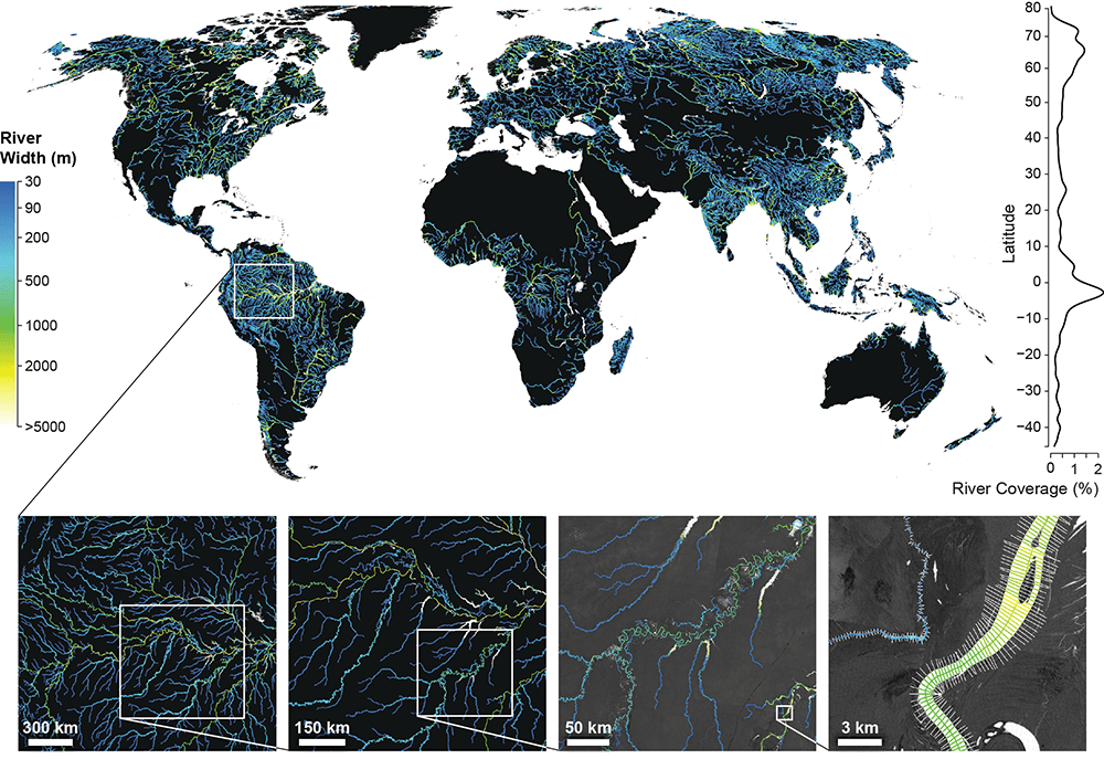
“We added up all the rivers and streams around the world [and] got an area larger than the size of Texas. The estimate was significantly larger than the previous best estimate, particularly in the Arctic.”
On the other hand, the researchers estimated that the surface area of rivers and streams in many developed parts of the world was less than expected.
“We think that there is less river water in these areas because humans are modifying the river system,” Allen said. “Water withdrawal and leveeing might be causing rivers to be narrower and more scarce than they would be otherwise.”
Rivers and streams naturally emit significant amounts of greenhouse gasses to the atmosphere. A key factor in estimating the amount of gas released is the amount of surface area occupied by rivers and streams (also called the fluvial network).
“A greater global total surface area implies that rivers and streams contribute more gasses to the atmosphere like carbon dioxide and methane than currently represented by carbon cycling models,” he said.
The GRWL Database already is being used for other purposes such as improving flood models and classifying surface water bodies, including lakes, canals and rivers.
“We think of this database as a first step to a lot more work,” Allen said.
The database will be used as a core dataset for the upcoming NASA Surface Water and Ocean Topography Satellite mission that will measure changes in river and lake water height globally.
The project was funded by NASA.
###
Media contact: Keith Randall, News & Information, at (979) 845-4644 or keith-randall@tamu.edu or George Allen at (530) 902-5024 or geoallen@tamu.edu.