The field of urban planning is gaining interest as cities around the world, including nearby Houston, are facing increased exposure to weather-related risks and hazards ranging from sea level rise and flooding to temperature build-up and urban heat island effect.
Philip Berke, professor of landscape architecture and urban planning at Texas A&M University, recently completed a five-year research project that examined 175 hazard mitigation plans adopted by counties and municipalities along the Gulf of Mexico and the U.S. Atlantic and Pacific Northwest coastlines. These local governments are required by the Federal Emergency Management Agency (FEMA) to adopt such plans to be eligible for pre-disaster and post-disaster mitigation funds.
According to the study, hazard mitigation plans in cities such as Houston are weak and underfunded. The plans are isolated from broader decisions about the location, density and design of urban development.
The National Research Council concluded that land use strategies that guide growth away from hazard areas are the most promising long-term solution to reducing risk; yet, land use strategies are rarely used. Instead, mitigation plans emphasize other mitigation approaches like levees, elevation of buildings and emergency management.
Furthermore, cities frequently rely on development policies that support housing and economic development in disadvantaged neighborhoods that are located in hazardous areas. Such well-intentioned policies that do not integrate mitigation measures ensure that poor neighborhoods will be flooded again and forced further into poverty.
“Losses are going to get worse as time goes on – catastrophic disaster events are going to become more the rule than the exception – and we’re just starting to see that,” Berke said. “Climate is involved, but it also has much to do with land use activities, and where we locate and how we design our cities. We can’t continue to place heavy reliance on engineering our way out of these situations because it’s not sustainable.”
As the toll of human suffering, especially for those who cannot afford to manage the risks associated with these disasters, and the federal deficit continue to increase, and the floodplains continue to widen, change is imperative, Berke said.
Coastal cities lack hazard mitigation plans that save lives, federal dollars
In the aftermath of hurricanes Harvey, Irma and Maria, Berke and other disaster experts were invited to address a meeting of the American Association for the Advancement of Science in Washington D.C. and, afterward, a briefing with Congressional staffers. Berke’s presentation, “Planning for Community Resilience,” laid out improved disaster mitigation strategies and government policies for scientists and policymakers.
“We need better science to determine where hazards are going to happen, where they are going to be most severe and how they are related to climate change, and we need to know the safe areas to build and rebuild,” Berke said. “We need to figure out how we are going to guide future growth and invest in flood protection, and we need to identify areas where returns on investment are viable.”
The study, supported by the Department of Homeland Security and the National Science Foundation (NSF), found that most of the coastal communities do not have an overarching strategy for building urban disaster resilience and lack coordination between multiple urban systems, including land use activities, natural environments and public infrastructure investments, particularly in Texas.
The city plans generally lack strong fact-based assessments revealing the interdependencies among different urban systems. For example, the researchers found many instances where the comprehensive plans included tax incentive policies to stimulate economic development in hazardous areas even though the local hazard mitigation plans identified the same areas as experiencing severe repetitive losses from hazard events and qualifying for federal funds for buyouts.
Too much emphasis is placed on individual hazard mitigation projects.
“Relocate this building, strengthen that other building, put a stormwater detention pond over on this side of town to prevent flooding of those six blocks,” Berke said. “It’s difficult to provide infrastructure efficiently and make wise land use decisions with this type of stove-piped decision-making and without an overall integrated approach to becoming more resilient.”
By operating city infrastructure systems independently without coordination, many coastal cities across the U.S. have urbanized high hazard areas and built highways that continually stimulate land use activities without any land-use controls in place. This often involves growing expanses of impermeable concrete that pave over critical environments such as wetlands and prairie lands that absorb floodwaters, thereby increasing downstream runoff.
Homes purchased by residents in areas outside floodplains are now well within them due to increased runoff from upstream development, and those that are not might be in a matter of a few years, Berke said.
“Houston, for example, is home to one of the largest populations of engineers of any city in the world and is accustomed to engineering its way out of problems without conducting a lot of urban land use planning,” Berke said. “With the numbers of homes damaged and the residents affected increasing with each disaster, the idea of accommodating them just became daunting over time, and as a result, residents stayed in place and rebuilt their homes with federally-backed flood insurance and disaster recovery funds.”
Historically, many coastal cities have ignored FEMA regulations after disasters to avoid forcing low-income residents from their homes when they cannot afford to elevate or relocate their homes to areas without flooding, Berke said.
“So then the cities are violating FEMA’s National Flood Insurance Program, and before Harvey, the program was $25 billion in the hole, and we’re paying for it as a society,” Berke said. “We need to both reduce financial losses and support socially-just rebuilding that is affordable.”
Houston and other cities affected by recent hurricanes are receiving a mass infusion of federal dollars, and they need to have urban plans in place in order to make wise investments. This requires making a multi-billion dollar investment to gradually buy people out of homes that keep flooding and help cities direct development to safer locations, he said.
“That’s a beginning. We have to thoughtfully plan ahead and anticipate, and that’s hard to do right after a disaster,” Berke said. “Houston is an amazing, dynamic city, and I really believe it has the capacity and the will to do these things, but it’s going to take strong leadership.”
Residents, city planners critical in shaping the future of their communities
Residents need to envision the cities in which they want to live in the future, and city planners need to develop strategies to turn those ambitions into realities. Cities need to infuse the best possible data from scientists and engineers who study hazards and climate into quality urban planning, Berke said.
For example, Norfolk, a coastal city in Virginia, has crafted a proactive and integrative strategy in its approach to dealing with the negative consequences of sea level rise and potential hurricanes. With guidance from Berke and his team, including Associate Director of Texas Target Communities Jaimie Masterson and doctoral students Matt Malecha and Siyu Yu, community members have determined a holistic vision of resilience for their city and developed a plan to reach their goals.
Without the financial ability to invest in structural flood controls to protect the entire city, Norfolk made the informed decision to enhance its downtown – a key economic asset at high risk of flooding – by investing in flood control infrastructure and encouraging additional dense mixed-use development.
The city developed a gradual retreat strategy for established residential neighborhoods in high-risk flood areas through voluntary housing buyouts, maintaining but not expanding roads, and water and sewer utilities, and levying an additional tax to help low-income families in those areas move to higher ground.
They targeted less developed areas at low-risk of flooding for future water and sewer utility expansion, and made plans to increase residential densities, create walkable neighborhoods, and expand public transportation so residents in those areas can travel to downtown and around the city.
Recently, Berke and his team received additional grants to explore the holistic environmental resiliency and urban planning in more depth. They received a grant from FEMA, and in collaboration with colleagues in the Department of Civil Engineering and Bush School of Government and Public Service, a grant from the NSF to examine linkages between community engagement and planning for interdependent infrastructure systems in cities exposed to flood disasters and sea level rise.
“FEMA is investing in us because, as an agency, it is aligned with what we are doing to try to reduce risk, and the NSF is supporting our work to explore new ways to improve decision support tools aimed at building local capacity to proactive action,” Berke said.
Institute for Sustainable Communities facilitates resident involvement in neighborhoods
As director of the Institute for Sustainable Communities at Texas A&M, Berke is interested in helping community members engage in the process of improving the communities in which they live. The institute consists of five university entities that are conducting interdisciplinary research on sustainable communities, translating that research into action through engagement, and creating high impact learning experiences for students.
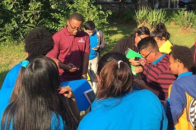
For every project, the institute performs long-range planning and allots a portion of the budget to facilitate fundamental community engagement. For example, doctoral students are working with high school students in several inner-city Houston neighborhoods to improve their stormwater drainage systems using a new iPhone technology application developed at Texas A&M.
The application enables the young residents to photograph the drainage systems in their neighborhoods with their iPhones and upload the images to the cloud. The institute then transports the students to educational sessions in College Station where they learn the rudiments of watershed science, infrastructure and engineering. By the end of their instruction, the students are analyzing characteristics of flooding in their neighborhoods and identifying ways their drainage systems are and are not working.
“We are working with young people in communities to integrate better stormwater management that they control rather than having to rely on the city or anyone else,” Berke said. “Our graduate students won national awards for their work.”
The Institute has developed collaborative partnerships between programs across the university, including Coastal Risk Reduction and Resilience at Texas A&M-Galveston, Community Infrastructure in the College of Engineering, Water Security in the College of Geosciences, Health and Environment in the School of Public Health, and Community Disaster Resilience and Texas Target Communities in the College of Architecture.
###
Media contact: Elena Watts, marketing and communications specialist, at 979-458-8412 or elenaw@tamu.edu