Want To Watch Aggieland Evolve Over The Decades? Now You Can – Digitally – Thanks To Librarians
In case you missed the first 100 years or so of the development of Aggieland, you now have the computerized opportunity to get a bird’s eye digital view of the campus as it is being built up — one color-coded marker at a time. You even have the option of clicking on the markers for data and historical photos of the associated buildings on interactive maps. It’s called “Mapping Historic Aggieland.”
Mapping the physical plant progression of Texas A&M over its 138-year history — including construction of the initial facility before it opened in 1876 as Texas’ first public institution of higher learning — presented a host of challenges. The challenges were compounded by the fact that many of the historic buildings that once graced the campus met their demise long ago — some to fire, some to age or obsolescence and at least one in a novel dramatic exit.
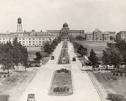
The earliest map in the exhibit dates back to 1919 and shows the layout of cattle pastures and cropland where the quad — the Corps of Cadets area of the campus — is now located. Even the “Bryan-College Interurban Trolley” route is prominently marked, as are more than 50 small buildings that represent faculty housing, later moved off campus.
As of this writing, 618 markers identify existing buildings as well as those which have been razed on this 5,200 acre campus.
It’s all made possible by the creative use of maps, aerial photos, and historic building photos with creativity applied by the resourceful staff of the Map & GIS (Geographic Information Systems) Library and Cushing Memorial Library and Archives, both part of Texas A&M University Libraries. Numerous individuals with longstanding Texas A&M ties also contributed with their institutional memories and other resources, while the Friends of the Sterling C. Evans Library contributed their funds.
“We want to tell the story of the A&M campus by linking our campus heritage to the present day, as well as share the rich variety of resources held in the library. Contributing to the preservation of Texas A&M campus history, this project uses cutting-edge geospatial technology to map more than 100 years of campus buildings and landmarks,” notes Kathy Weimer, a 1987 Texas A&M graduate who now serves as associate professor, curator of maps and coordinator of the Map & GIS Library.
Intrigued by the 1919 map, Weimer said she wondered when she saw it how campus locations have changed and evolved. Using geographic information system (GIS) software, Weimer and her team converted the historic map, and a number of aerial photos from 1932 to the present, into geographically correct digital formats.
“Geospatial technology allows us to utilize our archive of historic aerial photographs, maps, and data to create an interactive map allowing one to travel back in time and link personal memories to a campus location, even if the building is gone from Aggieland,” she explained.
She added that updates and enhancements continue to be incorporated into the endeavor — making it truly a work in progress. Aggies and others with pertinent historical or other relevant information are invited to share their thoughts, she added.
University Libraries Dean David Carlson explained that the use of the map background and sophisticated GIS software is a “unique presentation method” among library exhibits.
“There is no other library that I am aware of that has built such a fascinating interactive exhibit using historical campus maps and photos,” he said. “Our staff are quite technologically advanced and have pushed the digital boundaries to use this mapping approach to share the library collection with Aggieland, as well as Aggies around the state and worldwide.”
Want to view a building razed long ago? No problem. Information and pictures of the site are just a click away. You even get a historical nugget with each click, if warranted.
Take Guion Hall, for example. With Gothic pillars gracing its entrance, the auditorium was a landmark for decades and the site for just about every cultural event or major meeting that transpired on campus between 1918 and 1971. Age and the advent of air-conditioning led to the wrecking-ball demise of the stately structure — with photos of that, too.
A bit more digital exploring will reveal what stands on the site formerly occupied by Guion Hall. That would be the Rudder Theatre Complex, which today serves many of the same functions as Guion and, coupled with the adjacent Rudder Tower, has become a campus landmark in its own right.
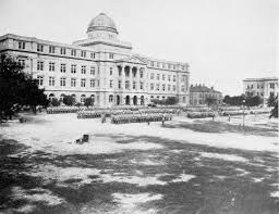
The first two markers to show up interactively, zero in on the sites of what was formally named the Main Building and became affectionately known as “Old Main” and Seward’s Hall, later renamed Gathright Hall, honoring the first president of the college. They were built in 1875 and 1876, respectively. Old Main was rendered useless by an untimely fire in 1912, and its remains were subjected to cannon fire — apparently cannon balls being a forerunner to the wrecking ball. Gathright remained a campus fixture until 1933.
It would be more than a decade after the opening of Old Main and Gathright before construction was again seen on campus, with Pfeuffer Hall (1887) and Austin Hall (1888). They endured until 1954 and 1955, respectively.
To make navigating the site easier, it is structured along the lines of eras reflecting campus historical time periods: Early Years (1875-1914), War Years (1915-1945), Rudder Era named for President Earl Rudder even though his presidency did not span the entire period (1946-1976), and The Second Century (1977-1999). Numerous markers reflect the campus growth from 2000 to the present.
Website visitors will also be able to “walk” in the path of Aggie traditions, such as Bonfire, and view such landmarks as Military Walk as they existed throughout the decades.
The site includes a “how-to-navigate” video.
Beyond the 1919 map and 1932 aerial photos, visitors to the digital collection can view other aerial photos from 1940, ’64, ’79, ’83, ’87, ’94, 2004 and 2011. Visitors can zoom in and out of the map, click on the colored markers representing buildings, and see photos of the buildings.
The popular campus creamery, which was razed in 1995, is among the landmarks pinpointed on the map.
“I enjoyed an occasional A&M-made ice cream at the creamery, since I lived in a southside dorm,” Weimer recalled. “When I saw the photo of the creamery included in this collection, it brought back memories.”
Since most of the people who helped make the project a reality are Aggies, it could well be considered a labor of love. In addition to Weimer, David Chapman, ’67, recently retired university archivist, and Lyndsey Raney ’05, who currently works with the university archives, are among those acknowledged in the credits on the website. A listing of all the project participants, many of whom also are Aggies, is prominently included on the website. The project relies heavily on two books well known to many Aggies: A Centennial History of Texas A&M University 1876-1976 by Henry Dethloff, retired Texas A&M professor of history, and Here We’ll Build A College by the late Ernest Langford, who headed the university’s architecture faculty for 27 years, until 1956.
Have a comment about the project or a suggested addition or modification? If so, send it to Weimer and her team at mappinghistoricaggieland@library.tamu.edu.
So, stay tuned and check back over the coming years, being mindful that the campus will never be completely built — and that’s good, that’s progress.
This article originally appeared in the Texas Aggie magazine.
Kathy Weimer, mappinghistoricaggieland@library.tamu.edu.