Sharing The Land Initiative Resolves Land Disputes In Africa
Texas A&M University’s Center on Conflict and Development, part of its College of Agriculture and Life Sciences, is helping to peacefully resolve land disputes in the Democratic Republic of the Congo, DRC, through the Sharing the Land initiative.
Land disputes often lead to conflict in the eastern DRC and other nations in Africa and beyond. Through its work in the DRC, the Sharing the Land initiative is developing a template that could be used to help resolve land disputes in other economically developing nations around the world.
Sharing The Land (STL) is a program of the Integrated Research Institute(IR) at the Christian Bilingual University of Congo(UCBC) based in Beni, North Kivu. The Texas A&M center is collaborating with the institute and other stakeholders to identify and apply innovative approaches to meet the need for effective land management in the DRC.
According to the IRI, 80 percent of cases in the courts and tribunals of the region are related to land disputes.
“Unclear land policy and inadequate documentation of land rights has led to violence throughout the Eastern Congo,” said Ed Price, professor in the Department of Agricultural Economics and Howard G. Buffett Foundation Chair on Conflict and Development. “Workable solutions found through this initiative can serve to help avoid or resolve similar land disputes in other conflict-affected or fragile countries of the world.”
What Is Sharing The Land?
The Sharing the Land program started in 2015 with two consecutive $25,000 research grants from Texas A&M AgriLife Research, with funds from the USAID Higher Education Solutions Network*.
The original STL team consisted of UCBC students and IRI staff, including Archip Lobo, project manager; Serge Vuthegha, GIS technician; Adelphine Angemito, IRI director of finance and assistant to the director; Christina Mukongoma, communications and public relations specialist; and Kyle Hamilton, IRI director. Currently, Lobo serves as a program consultant and Vuthegha serves as project manager as well as the team instructor on GIS and GPS technology.
“STL works by involving community members in defining solutions for land issues and introducing accessible technology to map and document land tenure,” Price said. “It has the potential to resolve and prevent land disputes for communities throughout the DRC and Africa.”
The U.S. Agency for International Development, USAID, has also funded a research-to-action plan for Sharing the Land. That plan has been developed by the STL team and Population Reference Bureau under its Research Technical Assistance Center.
Price said Sharing the Land aims to promote peace by facilitating transparent, fair and equitable land-ownership practices in eastern DRC. To reach this goal, the initiative is using research, technology, community engagement and public sector involvement to produce a sustainable, effective and transparent land registry system for North Kivu.
Participatory Approach
Sharing the Land builds on the Social Tenure Domain Model developed by the Global Land Tools Network. It is described as a “pro-poor, gender- neutral” model that uses a participatory approach to bring together land stakeholders and beneficiaries to find solutions for community land disputes.
Through engaging stakeholders and employing the latest technology, the Sharing the Land program was able to develop and apply methods to construct a digital base map of a neighborhood in the town of Beni in Eastern DRC. The effort, which included 531 land claims and related conflict data, was an STL pilot project funded by the initial AgriLife Research grant.
“In doing this, Sharing the Land developed a model and framework for improving the technical aspects of DRC’s land administration,” Price said. “Thanks to additional funding from the U.N., this model was expanded to the city of Goma in North Kivu. With this expansion, it became the first of the Transformative Solutions projects in which the Center on Conflict and Development was involved to reach more than a million beneficiaries.”
Sharing the Land also uses a “Fit-for-Purpose” approach endorsed by United Nations Human Settlements Programme and Global Land Tools Network to respond to each community’s needs through a spatial, legal and institutional framework.
This participatory process is designed to:
- Secure the right to own and benefit from land in both formal and customary ways
- Develop formal and informal transparent processes for preventing and resolving land conflicts
- Adopt land information systems to digitally track land rights
- Promote transparency, accessibility and stakeholder participation in defining land, assigning rights, resolving conflict and documenting records
“Ensuring the voices of the community are heard is at the core of the STL process,” Price said. “Participatory activities include organizing community listening sessions, hosting public forums and holding one-on-one meetings with key stakeholders.”
He also noted Sharing the Land team members provide hands-on training to land administration surveyors on best practices for land management. They also work with surveyors to improve their use of digital land-mapping tools.
“This helps local land administration offices improve the effectiveness and transparency of their record-keeping practices by introducing more accessible, electronic land records,” Price said. “It also improves overall data quality by incorporating the use of satellite data into local land information systems. These images can help support conflict mediation dialogues at the community level.”
Improving Land Mapping, Management Through Technology
Sharing the Land employs both GIS and GPS technologies and community organizing principles, said Leslie Ruyle, assistant director of Texas A&M’s Scowcroft Institute of International Affairs at the Bush School of Government and Public Service. Ruyle was involved with the Sharing the Land initiative for several years while a staff member at the Center on Conflict and Development. She now serves as a program advisor.
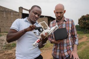
“The STL initiative is primarily led by local students at the UCBC and employs an innovative approach to aggregating, mapping and publicizing land ownership claims in the North Kivu region,” she said. “The use of GPS and GIS technology, including the employment of drones in creating maps and detailing land boundaries, has been huge in this process.”
Ruyle also noted much of the current land ownership recordkeeping in the eastern DRC is done with physical documents and harkens back to practices used in its colonial days.
“This means of land recording is antiquated, as paper documents can be lost, misplaced or destroyed, so digitizing the records is another important aspect of the effort,” she said. “And using modern GPS and GIS technology to help establish boundaries provides a degree of precision and level of detail that could not have been imagined in the past.”
Early Texas A&M Efforts To Address Land Disputes
Price said the concept of mapping and registering land use and land claims as a way of reducing conflict began prior to the Sharing the Land initiative.
“During Texas A&M’s involvement in the USAID Pastoral Engagement, Adaptation and Capacity Enhancement*, or PEACE, project in Afghanistan, we applied remote sensing to range management. In the process, we also discovered pastoral land tenure was the biggest problem facing agriculture there,” he explained. “Subsequently in Iraq, Ghana and the DRC, we increasingly observed that unclear land-use rights often lay at the heart of armed conflict.”
Price said to help find ways to resolve this problem, a partnership was formed with Stewart Title Company of Houston. The Howard G. Buffett Foundation funded Stewart Global Solutions and Texas A&M’s Department of Agricultural Economics to use handheld GPS devices to map farms in Ghana.
Led by Jill Urban-Karr, an executive director at Trimble Navigation Ltd. and member of the Texas A&M College of Geosciences Advisory Council*, and Fred Boadu, a professor in the Department of Agricultural Economics, this effort became the basis for informal, community-based land registration in Ghana.
“That essentially served as our proof of concept,” Price said. “Stewart Global Solutions then partnered with Texas A&M AgriLife in a successful proposal to USAID for comprehensive research on conflict and development. This led to the establishment of the Center on Conflict and Development.”
He said the center later worked with USAID to issue a worldwide invitation for “Transformative Solutions” to mitigate armed conflict.
“We were pleased and excited to receive a proposal from the Bilingual Christian University of the Congo to experiment with community-led land mapping as a solution,” Price said.
What’s Next
The process the IRI has developed for Sharing the Land is being replicated in other provinces of the DRC and has already garnered the attention of other African nations.
Most recently, Sharing the Land has partnered with UN-Habitat and Global Land Tools Network to enhance their land information and management system by employing a customized version of the network’s Social Tenure Domain Model in the Masiani neighborhood of Beni. It has also branched out into other efforts within the DRC.
“In partnership with GLTN and UN-Habitat, Sharing the Land is currently expanding its work to three new sites in rural areas of the North Kivu, South Kivu and Ituri provinces,” Price said. “Sharing the Land will work with DRC’s government and local community members to integrate community land-use planning processes in developing and piloting this new system.”
As word of the Sharing the Land program has begun to spread in Africa, the Senegalese government has shown interest. Facilitated by UN-Habitat and Global Land Tools Network, project manager Vuthegha recently met with government representatives and participated in a technical meeting about possible application of the Sharing the Land concept in Senegal.
“We are hoping to export the success we have had with the Sharing the Land program in the DRC to Senegal to help them resolve their land disputes and, by extension, avoid conflict and promote peace in that country as well,” Price said. “Then we’d like to see other developing nations in Africa and elsewhere adopt the Sharing the Land approach as a means of helping end land-based conflicts globally.”
* This link is no longer active and has been removed.
This article by Paul Schattenberg originally appeared on AgriLife Today.