When Storms Roll In, Texas A&M Steps Up To Aid Weather Forecasters
On April 22, the first day of a multi-day severe weather outbreak in the southern United States, the Department of Atmospheric Sciences at Texas A&M University acted quickly to provide regional, timely field data to official forecasters.
“We were the National Weather Service’s eyes for a tornadic supercell thunderstorm,” said Don Conlee, instructional professor of atmospheric sciences.
Conlee, graduate student Montana Etten-Bohm, and Christopher Nowotarski, assistant professor, coordinated with the National Weather Service (NWS) Houston-Galveston and Fort Worth offices to provide upper-air and radar observations to help enhance NWS forecasts of the event.
Observational balloons are normally sent out every 12 hours — at 7 a.m. and 7 p.m. local time — but Texas A&M and much of Central and Southeast Texas are caught in an observation gap that includes the Austin, San Antonio and Houston metropolitan areas. They take a collection of data called soundings.
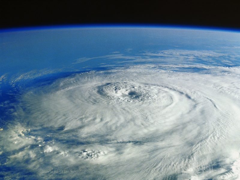
Etten-Bohm, Nowotarski and Conlee launched a balloon on campus in the late morning that day. The data it retrieved suggested that supercell thunderstorms, rotating thunderstorms highly coincident with severe weather and significant hail were all expected in the region.
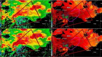
Additionally, the distance between the Brazos and Trinity river valleys and NWS radar sites in Houston, Fort Worth, Temple-Killeen and Shreveport can cause problems with radar coverage of the lower levels of the atmosphere, limiting the reliability of the data used to declare storm warnings. The Aggie Doppler Radar (ADRAD) atop the Eller O&M Building on the Texas A&M campus was used to cover the region during the outbreak, and helped provide the NWS in Houston with vital radar information.
Helping Save Lives
The April 22 storm did in fact result in a tornado.
Data from the ADRAD helped the NWS issue severe thunderstorm and tornado warnings for a strong supercell thunderstorm that passed over East Texas near Trinity around 7 p.m. that night.
Preliminary surveys of the Onalaska tornado from NWS Houston and the Polk County Office of Emergency Management reported an EF-3 tornado with estimated peak winds of 140 mph that touched the ground for 33 miles and large hail with a max-measured diameter of two inches, resulting in 33 injuries and 3 deaths — making it the deadliest tornado to hit the area since 1987.
That particular storm was sustained long after leaving the Brazos Valley, producing tornadoes in Louisiana until it finally dissipated in Mississippi over six hours later. Nowotarski is planning on taking the upper-air and ADRAD data from the storm to investigate how the storm persisted for such a long period of time and continued to produce tornadoes well after sunset.
Brandon Gale, graduating meteorology senior, safely followed the storm to collect and report hail samples. Normally, undergraduates would be heavily involved in both radar and weather balloon observations, but that day they were not able to assist due to pandemic protocols.
The significance of the event shows the necessity of observations during the course of the weather outbreak, and how Texas A&M is afforded the opportunity to coordinate with the local NWS offices to help forecasters protect the lives of the people who live here.
“The Texas A&M radar provided important detail on the storm structure as it crossed Brazos and Grimes counties that was not evident on the more distant NWS radars,” said Dan Reilly, warning coordination meteorologist for the NWS Houston/Galveston office. “Given its proximity to the storm, it was able to see features with higher resolution and closer to the ground than could be seen by other radars. This information was critical for NWS warning decision-making for the storm.”
Not The First Time
This is not the first time that Texas A&M Atmospheric Sciences students have aided with collecting data for severe weather. On May 20, 2019, during a forecasted high-risk day from the Storm Prediction Center, NWS Fort Worth requested an upper-air sounding to aid their diagnosis for severe weather for eastern Texas, and the Student Operational Upper-air Program (SOUP) carried out the requested sounding.
ADRAD operations also helped keep local communities safe earlier this year, on March 4, when the KGRK NWS radar in Temple-Killeen was unavailable. The NWS in Fort Worth made use of ADRAD data to make warnings on storms moving through central Texas and communicate the potential danger of those storms to local Emergency Managers and news media. Those storms produced winds over 60 mph and hailstones larger than one inch in diameter in Brazos and Robertson counties early in the morning.
Texas A&M students also help local NWS offices through the SKYWARN spotter training program. Last year, students reported a tornado touched down on April 24 during a thunderstorm that was not well-sampled through NWS radar. Though ADRAD was not operating that day, students were able to identify the storm, and those students were able to help NWS identify the threat for thunderstorms in spite of the lack of radar data.
Media contact: Leslie Lee, College of Geosciences, leslielee@tamu.edu