Luckily, Hurricanes Like Dorian Are Very Rare
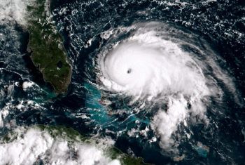
As Hurricane Dorian stalled over the Bahamas, the storm produced wind gusts of over 200 miles per hour for more than a day and caused widespread destruction. But Robert Korty, associate professor of atmospheric sciences at Texas A&M University, says that Category 5 hurricanes – the most severe and the status Dorian attained – don’t happen very often in the Atlantic.
“Category 5 storms are rare,” Korty said. “Dorian was only the 27th Atlantic storm to reach Category 5 level in the last 70 years. But worldwide, there has been growth in the small number that reach extreme intensities.”
According to figures from NOAA (National Oceanic and Atmospheric Administration), of the 10 most intense Atlantic hurricanes on record, 7 of them occurred in the last 20 years or so. These include Maria (2017), Dean (2007), Katrina (2005), Rita (2005), Wilma (2005) and Mitch (1998) and Dorian.
The others are Camille (1969), the Labor Day Hurricane of 1935 and Gilbert (1988).
Dorian had maximum sustained winds of 185 miles per hour (gusts over 200 mph), and this puts it in elite company, tying it with two others for the second strongest ever measured in the Atlantic, Korty said.
Korty said that in addition to its immense power, another aspect that led to the destruction in the Bahamas was that the storm stalled and pounded the same land for more than a day, resulting in catastrophic damage Great Abaco and Grand Bahama Islands.
“We have seen the average speeds at which hurricanes move trend slower over the last several decades, but we are not completely certain why,” he said. “We believe there are connections to larger climate changes, but this is a question we need to better understand. When storms stall, their punishing impacts are compounded. Harvey and Dorian are graphic illustrations of these.”
Korty doesn’t think ideas about storm modification are feasible.
“People sometimes ask if there anything we can do to prevent these strong storms from happening,” he said. “In my opinion, none of the ideas raised over the last 60 years would be viable, effective, or wise.”
Korty added that advances to weather models and our confidence in them have improved the accuracy of forecasted tracks for storms like Dorian.
“It is remarkable to me that a Category 5 hurricane sat less than 200 miles east of South Florida, yet there was sufficient confidence in the forecast to know that hurricane warnings were unnecessary for Miami,” he said. “That wouldn’t have been possible 20 years ago, and that is a remarkable achievement for our field.”
Media contact: Robert Korty, 979-847-9090, korty@tamu.edu.
