Texas Sea Grant College Program Uses UAVs To Monitor ‘Red Tide’
As the red tide continues to linger off the South Texas coast, the Texas Sea Grant College Program at Texas A&M University is collaborating with two other Texas universities to test the effectiveness of unmanned aerial vehicles (UAVs) to monitor the harmful algal blooms.
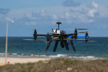
At the request of Tony Reisinger, the Cameron County coastal and marine agent for Texas Sea Grant and Texas A&M AgriLife Extension, Dr. Jinha Jung, assistant professor of engineering at Texas A&M University-Corpus Christi, took two UAVs to the lower Texas coast to determine if they could be viable and cost-effective options to use instead of satellites.
“Right now, we track red tide movement with satellite flyovers,” Reisinger said. “Not only is that very expensive, but cloud cover sometimes limits data collection. We currently determine red tide concentrations by manually taking hundreds of water samples to measure red tide cell concentrations. A multi-spectral equipped UAV could quickly do all that from the air in a fraction of the time and expense, if concentrations can be correlated with color change.”
Jung flew the two UAVs out of the University of Texas Rio Grande Valley Coastal Studies Laboratory on South Padre Island. Each spent 20 to 25 minutes in the air, flying about half a mile out to sea and back while recording video and a series of still images. One UAV, a DJI Phantom 4 camera drone, used a natural color sensor. The other, a 3D Robotics RTF X8+ Multicopter, was outfitted with thermal and multispectral sensors. A multispectral sensor captures data from different parts of the electromagnetic spectrum, including outside the spectrum visible to humans.
Red tides in Texas are caused by a bloom of toxic algae called Karenia brevis. There is growing interest in the agricultural applications of UAV remote sensing, but it also may have the potential to assess algae bloom movement, cell density and fish kills, the latter useful in determining fisheries resource impacts, Jung and Reisinger said.
“A UAV can be programmed to follow a predetermined flight path, cameras can be programmed to operate remotely, and pictures, sensors and multispectral imaging can be used to measure, determine and document growth in crops like corn,” Jung said. “Flights like this help us test to see if the same can be said for red tide growth.”
This was Jung’s second visit to South Padre Island with his UAVs; he conducted similar trials last October during the red tide then.
The current Texas red tide stretches from the Lower Laguna Madre to just north of Aransas Pass. The algae can kill fish, shellfish, mammals and birds. While it’s not life-threatening for humans, red tide toxin can aerosolize when cells are broken up by the surf, causing temporary symptoms including burning eyes, coughing, sneezing, skin irritation and respiratory problems, Reisinger said. People with asthma or other respiratory problems should avoid exposure. K. brevisconcentrations tend to be patchy, and levels of respiratory irritation can vary locally based on nearby concentrations, ocean currents, and wind speed and direction.
Members of a volunteer group, called the Red Tide Rangers, was started by Reisinger in 1992 in partnership with the UTGRV Coastal Studies Laboratory and is now managed by the laboratory. Its members visit sites around South Padre Island daily to collect water samples, check for fish kills and gauge the severity of aerosolized toxin.
These specially trained citizen scientists then examine the samples at the Coastal Studies Laboratory to count the number of cells of K. brevis—a time-consuming process. The data they collect are sent to the state, which uses that information to issue timely advisories to the public, fishermen and resource managers. The information is also used to ground-truth satellite tracking of red tide by the National Oceanic and Atmospheric Administration.
“Using UAVs may eventually be an excellent way to monitor these red tide algal blooms,” Reisinger said. “It has the potential to save state and federal agencies lots of time and money by tracking the movement and concentration of the bloom, and conducting fish-kill counts along the shore, which are measurements now taken by hand, so to speak. All that takes lots of man hours and resources.”
Interested individuals can check the red tide status online for Texas at http://tpwd.texas.gov/ and for the entire Gulf Coast at http://www.facebook.com/Habredtidewatchnoaagov/?fref=nf.
You can follow the Red Tide Rangers on Facebook or find more information at http://seagrant.noaa.gov/WhatWeDo/CurrentFocusAreas/EnvironmentalLiteracyandWorkforceDevelopment/CitizenScienceProjects.aspx or http://www.utrgv.edu/csl/public-service/red-tide/index.htm.
Media contact: tamunews@tamu.edu.